

Si-Tex Orion 10.4” Chartplotter Fishfinder for SALE
$ 1.199,00
Brand: Si-TexBuy the Si-Tex Orion 10.4” Chartplotter Fishfinder with C-MAP 4D, dual-frequency sonar, internal GPS, hybrid touchscreen and NMEA 2000 support.
Si-Tex Orion 10.4” Chartplotter Fishfinder
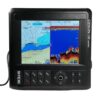
Navigate accurately and locate fish with confidence using the Si-Tex Orion 10.4” Chartplotter Fishfinder. This multifunction marine display combines detailed chartplotting, multi-satellite GPS positioning, and a powerful digital echo sounder in one rugged and easy-to-operate unit.
Its 10.4-inch color LCD features hybrid controls, allowing operators to use either the touchscreen or heavy-duty silicone keypad. The display can be mounted in portrait or landscape orientation, with a menu command automatically rotating the screen to suit the selected helm layout.
Accurate Multi-Satellite Navigation
The built-in 52-channel receiver supports GPS/GNSS, GLONASS, and Galileo satellite networks for dependable positioning. An internal GPS antenna simplifies installation, while support for an optional passive external antenna provides flexibility for enclosed or obstructed mounting locations.
C-MAP 4D cartography delivers useful navigation features such as vector charts, high-resolution bathymetry, depth shading, Dynamic Tides and Currents, Easy Routing, and detailed marina plans.
The Orion can store up to 100,000 waypoints and marks, 50,000 track points, and 100 routes, making it suitable for cruising, sportfishing, and commercial fishing operations.
Integrated Digital Fishfinder
The built-in dual-frequency digital echo sounder supports 50 and 200kHz operation with compatible transducers. Available sonar views include single- or dual-frequency Normal mode, Bottom Lock, Bottom Zoom, and A-Scope.
Additional fishfinder functions include automatic or manual gain and range, adjustable pulse length, White Line/Black Line bottom discrimination, water-temperature data, selectable image speeds, and depth shifting.
An optional 340kHz Down Scan transducer enables high-definition sonar imaging at depths up to approximately 328 feet.
Key Features
- 10.4-inch color LCD with LED backlighting
- Hybrid touchscreen and heavy-duty silicone keypad
- Integrated chartplotter and digital fishfinder
- Internal 50/200kHz dual-frequency echo sounder
- Optional 340kHz Down Scan capability
- Portrait or landscape mounting orientation
- Bracket-mount or flush-mount installation
- Built-in 52-channel GPS receiver
- Supports GPS/GNSS, GLONASS, and Galileo
- Compatible with C-MAP 4D cartography
- Commercial fishing plotter mode
- Split-screen chart and echo-sounder display
- NMEA 2000 and NMEA 0183 connectivity
- Internal GPS antenna
- Automatic day and night display modes
- Bluetooth support for compatible Android devices
- Stores 100,000 waypoints and marks
- Stores 50,000 track points and 100 routes
Specifications
| Specification | Details |
|---|---|
| Model | ORIONCF |
| Display size | 10.4 inches |
| Display type | Color LCD with LED backlight |
| Resolution | SVGA, 800 × 600 pixels |
| Controls | Hybrid touchscreen and keypad |
| Orientation | Portrait or landscape |
| Cartography | C-MAP 4D |
| GPS receiver | Internal 52-channel |
| Satellite networks | GPS/GNSS, GLONASS and Galileo |
| Positioning accuracy | Approximately 2.5 m, autonomous CEP 50% |
| Navigation update rate | 1Hz or 5Hz |
| Map scale | 0.05–1,500 nautical miles |
| Waypoint capacity | 100,000 |
| Track capacity | 50,000 points |
| Route capacity | 100 routes, 20 waypoints per route |
| Sonar frequencies | 50/200kHz |
| Optional Down Scan | 340kHz |
| Sonar output | 600W; supports configurations up to 1.5kW |
| 600W depth range | Approximately 2.5–600 m |
| 1.5kW depth range | Approximately 2.5–1,500 m |
| Sonar modes | Normal, dual frequency, Bottom Lock, Bottom Zoom and A-Scope |
| Image speeds | Eight selectable speeds plus stop |
| Networking | NMEA 2000 and NMEA 0183 |
| Power supply | 12–36V DC ±10% |
| Power consumption | 12W |
| Operating temperature | -15°C to +50°C |
| Mounting | Bracket or flush mount |
Maximum sonar depth depends on the transducer, installation, water conditions, bottom composition, and operating frequency.
Package Contents
- Si-Tex Orion 10.4” chartplotter/fishfinder display
- U.S. C-MAP 4D chart card
- Protective display cover
- Mounting bracket
- Bracket knobs
- Fuse and mounting hardware
- Power cable
- Owner’s manual
Not included: Sonar transducer. A compatible transducer must be purchased separately.




Reviews
There are no reviews yet.