

B&G Zeus S 7 Chartplotter for SALE
$ 650.00
Brand: B&GBuy the B&G Zeus S 7 Chartplotter with a SolarMAX touchscreen, sailing modes, GPS, SailSteer, C-MAP support, sonar and marine networking.
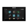
B&G Zeus S 7 Chartplotter
Make sailing navigation easier with the B&G Zeus S 7 Chartplotter. Designed specifically for sailors, this compact multifunction display combines a modern touchscreen interface, dedicated sailing tools, precise GPS positioning and comprehensive system integration.
The 7-inch SolarMAX IPS display delivers sharp detail, excellent sunlight visibility and wide viewing angles—even when viewed through polarized sunglasses. Its customizable interface, drag-and-drop layouts and guided Setup Wizard make important navigation and sailing information easy to access.
Dedicated Sailing Modes
Zeus S automatically presents the most relevant information for your activity through specialized sailing modes:
- Cruise Mode: Prioritizes charts, route information and essential sailing data.
- Race Mode: Provides quick access to StartLine, race routes, timers and performance information.
- Anchor Mode: Displays information designed to help monitor the vessel while anchored.
- Night Mode: Reduces glare and improves screen readability in low-light conditions.
Advanced B&G Sailing Features
The Zeus S 7 includes enhanced versions of B&G’s sailing tools:
- SailSteer: Combines wind, heading, tide, layline and waypoint information into a single visual display.
- Laylines: Displays predicted tacking and gybing routes directly over the chart.
- StartLine: Helps racing sailors monitor time, distance and position relative to the starting line.
- SailingTime: Provides realistic arrival-time calculations for routes that require tacking.
- C-MAP Safety Alerts: Provides warnings for potential grounding and hazardous charted objects when using compatible charts.
Compatible wind, speed, depth and heading sensors may be required to access all advanced sailing calculations.
C-MAP X-Generation Chart Support
Zeus S supports C-MAP DISCOVER X and C-MAP REVEAL X cartography. These next-generation charts offer clear presentation, tides and currents, autorouting, depth information and simplified chart management.
The standard global model includes a worldwide basemap that is not intended for navigation. A detailed regional chart card must be purchased separately unless your retailer specifically lists a C-MAP chart as included.
Complete Marine-System Integration
Built-in NMEA 2000, Ethernet, Wi-Fi and Bluetooth allow the Zeus S 7 to operate as the center of an integrated sailing system. Connect compatible B&G autopilots, HALO radar, Triton² and Nemesis instruments, AIS equipment, wind sensors and other onboard electronics.
A built-in 9-pin XSONIC sonar port supports compatible single-channel CHIRP, 50/200 kHz, HDI and Active Imaging transducers. The display can also receive video from compatible IP cameras.
Key Features
- Bright 7-inch SolarMAX IPS touchscreen
- 1024 × 600-pixel screen resolution
- 1,200-nit sunlight-viewable display
- Wide 85-degree viewing angles
- Visible through polarized sunglasses
- Dedicated Cruise, Race, Anchor and Night modes
- SailSteer and Laylines
- StartLine and racing tools
- C-MAP Safety Alerts with compatible charts
- Supports C-MAP DISCOVER X and REVEAL X
- Integrated 10 Hz GPS receiver
- 9-pin XSONIC 1 kW sonar port
- Single-channel CHIRP sonar support
- Compatible with HDI and Active Imaging
- HALO dome and open-array radar compatibility
- B&G autopilot integration
- NMEA 2000 and Ethernet networking
- Integrated Wi-Fi and Bluetooth
- B&G App integration
- IP-camera support
- Customizable drag-and-drop interface
- Guided Setup Wizard
- Compact flush- or bracket-mount design
- IPX6 and IPX7 water resistance
Technical Specifications
| Specification | Details |
|---|---|
| Brand | B&G |
| Model | Zeus S 7 |
| Manufacturer part number | 000-15217-001 |
| Product type | Sailing chartplotter and multifunction display |
| Display size | 7 inches |
| Display type | SolarMAX IPS multi-touch |
| Display resolution | 1024 × 600 pixels |
| Screen brightness | 1,200 nits |
| Viewing angles | 85° top, bottom, left and right |
| Included cartography | Worldwide basemap—not for navigation |
| Supported charts | C-MAP DISCOVER X and REVEAL X |
| GPS | Integrated 10 Hz, 32-channel receiver |
| Position accuracy | Approximately 3 meters under suitable conditions |
| Sailing modes | Cruise, Race, Anchor and Night |
| Sailing features | SailSteer, Laylines, StartLine and routes |
| Sonar port | One 9-pin XSONIC, up to 1 kW |
| Sonar support | Single-channel CHIRP, 50/200 kHz, HDI and Active Imaging |
| Radar support | Compatible HALO dome and open-array radar |
| Autopilot support | NAC-1, NAC-2, NAC-3, NAC-D and H5000 |
| AIS | Receives compatible AIS data over NMEA 2000 |
| Networking | NMEA 2000 and Ethernet |
| Wireless | Wi-Fi and Bluetooth 4.0 |
| Memory-card slot | One microSD slot |
| Video | Compatible IP-camera support |
| Waypoints | Up to 6,000 |
| Routes | Up to 500 |
| Tracks | Up to 50 |
| Supply voltage | 12 V DC; 10–17 V operating range |
| Maximum power consumption | 11.5 W |
| Recommended fuse | 2 A |
| Water resistance | IPX6/IPX7 |
| Dimensions | 7.7 × 4.8 × 2.8 inches |
| Weight | Approximately 1.7 lb |
| Mounting | Bracket, panel or flush mount |
| Warranty | Two years |
Package Contents
The standard global-basemap package typically includes:
- B&G Zeus S 7 chartplotter
- Four-pin power cable
- U-bracket and mounting hardware
- Panel-mounting kit
- Corner clips
- Sun cover
- Product documentation





Reviews
There are no reviews yet.