
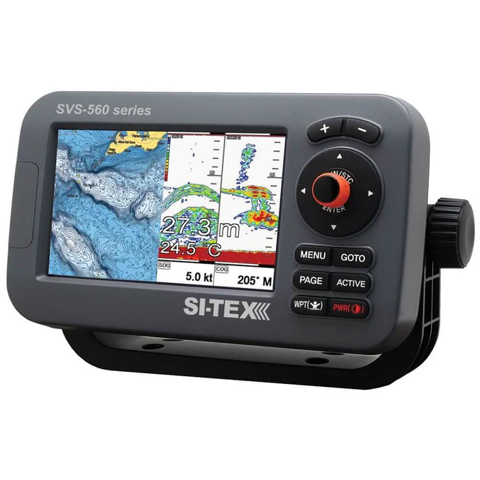
Si-Tex SVS-560CF with External Antenna for SALE
$ 583,00
Brand: Si-TexBuy the Si-Tex SVS-560CF with External Antenna featuring a 5-inch display, 52-channel GNSS and 600W dual-frequency sonar.
Si-Tex SVS-560CF with External Antenna
The Si-Tex SVS-560CF with External Antenna is a compact GPS chartplotter and digital fishfinder engineered for reliable marine navigation and detailed underwater imaging. Its external GPS antenna can be mounted with a clear view of the sky, making this configuration particularly suitable for enclosed helms, pilothouses, and installations where the display’s internal antenna may be obstructed.
A bright 5-inch color LCD with LED backlighting and an 800 × 480 resolution delivers clear charts, navigation data, sonar returns, and bottom detail. The integrated 52-channel GNSS receiver supports GPS, GLONASS, Galileo, and QZSS satellite systems for reliable positioning in different operating regions.
The built-in digital fishfinder delivers up to 600 watts of output power with dual-frequency 50/200 kHz operation. Available sonar modes include single or dual frequency, Bottom Lock, Bottom Zoom, and A-Scope. Automatic and manual controls for gain, range, and depth shift help optimize target separation and bottom visibility as water conditions change.
The chartplotter can store up to 20,000 waypoints, 100 routes, and 50,000 track points. C-MAP and compatible Navionics cartography support gives boaters flexibility when selecting charts for their cruising or fishing area. NMEA 0183 connectivity also allows integration with compatible marine equipment.
The external-antenna version is identified in SI-TEX’s current price list as SVS-560CFE. Transducers are sold separately, while the supplied chart card and geographic coverage may vary by package.
Key Features
- Combined GPS chartplotter and digital fishfinder
- Included external GPS antenna
- Ideal for enclosed or obstructed helm installations
- Built-in 52-channel GNSS receiver
- GPS, GLONASS, Galileo, and QZSS compatibility
- Bright 5-inch color LCD
- 800 × 480-pixel screen resolution
- LED backlighting for daylight readability
- Built-in 300/600W digital sonar
- Dual-frequency 50/200 kHz operation
- Single-frequency and dual-frequency sonar views
- Bottom Lock, Bottom Zoom, and A-Scope modes
- Automatic and manual gain and range controls
- Interference and noise rejection
- Stores up to 20,000 waypoints
- Stores 100 routes and 50,000 track points
- C-MAP and Navionics cartography compatible
- NMEA 0183 input and output
- Rugged IPX7 waterproof construction
Technical Specifications
| Specification | Details |
|---|---|
| Brand | SI-TEX |
| Model | SVS-560CF |
| External-antenna model | SVS-560CFE / SVS-560CF-E |
| Product type | GPS chartplotter and fishfinder |
| Display | 5-inch color LCD |
| Resolution | 800 × 480 pixels |
| Backlight | LED |
| GPS receiver | 52-channel |
| GPS antenna | External antenna included |
| Supported GNSS | GPS, GLONASS, Galileo and QZSS |
| Position accuracy | Approximately 2.5 m autonomous |
| Sonar output | 300W/600W |
| Sonar frequencies | 50/200 kHz |
| Maximum sonar range | Up to 600 m under suitable conditions |
| Sonar modes | Normal, dual frequency, Bottom Lock, Bottom Zoom and A-Scope |
| Waypoint capacity | 20,000 |
| Route capacity | 100 routes |
| Track capacity | 50,000 points |
| Chart compatibility | C-MAP and compatible Navionics cartography |
| Interface | NMEA 0183 input/output |
| Map datum | WGS-84 |
| Power supply | 12–36V DC |
| Power consumption | Approximately 7W |
| Operating temperature | −15°C to +50°C |
| Waterproof rating | IPX7 |
| Transducer | Sold separately |




Reviews
There are no reviews yet.